Even though I had driven late into the previous night, I knew I had to be up early today. The reason I had pushed long and hard for Ann Arbor was that two of my old ultimate teammates from Bates would both be in the area today. So when Funk woke me up to get Pope from the airport for breakfast, and then encouraged me to rummage around in his garden for food, I knew it was going to be an excellent day. Oddly enough, both Funk and Pope are from Alaska, both are super tall, super friendly, and are commonly referred to by only their last names… It must be some sort of Alaskan thing that us contiguous Americans will never understand.
After collecting Pope at the airport, we headed into Detroit for breakfast. A seemingly simple task was made far more dangerous by the obvious hazards of trying to caravan through a major urban area. My issues multiplied when I had to find somewhere to park. With a rocketbox, I was definitely too tall for the vast majority of the public parking garages in Detroit. Luckily, I found a open-air lot that I could park at… for a whopping $10! Once we had reconnoitered at the restaurant, we sat for an hour and change filling each other in on the events of the past years. Sadly, Pope and Funk were headed north and I was headed south, so we parted ways and I wandered downtown Detroit. At the waterfront, I parked myself in front of the GMC Renaissance Center and began reading about the impact of the automobile on the design of American roadways, infrastructure, and culture…. It seemed all too fitting.

With my parking about to expire, I buckled up for the drive south, setting a bearing for Toledo before curling east along the southern shore of Lake Erie. The speed limit of my route varied from 25 mph to 55 mph, which was both relaxing and, at times, frustrating. It was during this slow, ponderous drive that I realized that I had been following the Lake Superior Circle Tour route for quite some time. While circumnavigating the Great Lakes had never necessarily been a goal of mine, the past few days had surely made an impression. Who knows, that might be something to add to the bucket list.


Two swim stops and a lunch break later, I was rolling through Cleveland headed for the Cuyahoga River Valley and my first official national park. I didn’t know it then, but I was in for a surprise. As I write this, I realize that Cuyahoga Valley National Park was the perfect way to set the tone for my national park odyssey. Located in the heart of Cleveland, the Cuyahoga River Valley has been a center for outdoor recreation for decades. Achieving its status as a National Recreation Area in 1974, it transitioned to a full National Park in 2001. There is no backcountry here. No untouched wilderness. Its semi-urban location means that it has next to none of the solitude that the Tetons or Yellowstone espouse. Where other parks manage backcountry permits and wilderness camping, Cuyahoga Valley National Park promotes outdoor activity. With hundreds of miles of bike path, hiking trails, skiing trails, interpretation sites, communal gathering areas, this park is designed for the community that it serves. And they are taking advantage of it. In the afternoon I spent hiking around and wandering the park, I must have seen hundreds of people jogging, walking, biking, and relaxing alongside the canal path or on the forest trails. In a city the size of Cleveland, wilderness like this is almost unthinkable.
The main thoroughfare of the park has been laid out alongside the Cuyahoga River and the Ohio Canal. The former makes sense, while the latter needs a little explaining. We have all heard of the Erie Canal, which connected the Great Lakes to the Atlantic in 1825. The Ohio Canal had a similar purpose, to continue the Erie Canals connection to the Ohio River, and thus, to the Mississippi. Completed in 1833 and abandoned after massive flood damage in 1913, the remnants of the towpath alongside the canal is now a very popular recreation area. I wasn’t sure what to expect when I realized that Cuyahoga Valley National Park was indeed on my list of stops, but I am glad I followed through.

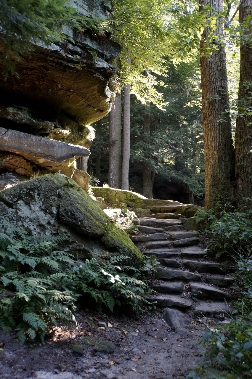
Instead of jogging the towpath, I opted for a hike up to the Ledges, a wonderful sandstone formation that rises in alongside the valley. In trying to find it, however, I realized that the Cuyahoga River Valley road system was exceedingly complex for what I would normally consider such a mundane physical feature. Roads crisscrossed the river constantly, which meant it took me far longer than I would have expected to arrive at my destination. Another factor in my circuitous route was my misinterpretation of the size of the park I’m sure my brain connected the ideas of “National Park” and “Cleveland”, pairing the two into an assumption of some small, hidden park. Hidden may be true, small would be an understatement. After a few wrong turns, I eventually did end up at my trailhead.

The trial began at a lodge called Happy Days, a remnant of the Civilian Conservation Corps work in the early 20th century. From there, it winds through the forest until it climbs to a ring of sandstone encircling a sizeable hill. That ring, and the intricate sandstone formations there, are what is fondly known as The Ledges. The pinnacles and exposed faces of sandstone are playful, intense, and highly accessible. The trail goes over, under, around, and through the formation, ending up at an exposed face that overlooks the valley. If not for the distant din of traffic, you would never be able to guess that two million people are lurking in the Cleveland metropolitan area.


I was thoroughly impressed by Cuyahoga Valley National Park, but I had to leave it behind for the day. A friend of mine from Bates, Danya, is working at The College of Wooster. Heading south, I left behind the suburbs and found myself driving through the rolling farms of northern Ohio. It looked rather familiar, having driven through many such farms in Wisconsin. There were less cows, a little more soy and corn, but pretty similar in the greater scheme of things. Then, something unexpected cropped up on the horizon, a Technicolor hot air balloon hanging not more than 500 feet above me. I craned my neck to see it before realizing that I was about to hit a stop light at a construction zone. Putting the car in park, I had a few minutes to photograph and ogle at this floating ball of gas. I’ve since added that to my bucket list… but maybe not over north central Ohio.

After my close encounter with the hot air balloon, I stumbled upon Wooster, where I settled in for a night of cooking, music, and conversation. Together with two of Danya’s childhood friends, we roasted garbanzo beans, sautéed brussels sprouts, caramelized onions, boiled sweet corn, and feasted on the fruits (and vegetables) of our labor. Two epically hospitable nights in a row and I am starting to feel spoiled!
As always, a map of the day’s adventure.
One Response
Susan Fey
Cleveland and the Cuyahoga River ALWAYS remind me of this iconic song. The river has actually been ON FIRE 13 times. https://m.youtube.com/watch?v=VtW8RkI3-c4