After my night in Port Angeles, I woke amid the interplay of persistent sun and relenting cloud cover. The fleeting rays hinted at the bright day that lay ahead. Leaning into a new day of exploration, I cruised over to the banks of the mighty Elwha River. Although that name may be unfamiliar to many of you, national attention focused on the dam as artistic installations, protests, and dam removal propositions came to a head in the early 90’s. The Elwha gathers precipitation and snow melt from the heart of the Olympics before tumbling northwards for 45 miles before spilling into the Strait of Juan de Fuca. The Elwha Dam and the Glines Canyon Dam, however, have hindered its tumbling waters for over 100 years. Almost a decade later, Congress passed the Elwha River Ecosystem and Fisheries Restoration Act. This legislation recognized the negative impact that the presence of hydroelectric systems had had one the ability of the river to transport glacial till and the ability of anadromous fish, like salmon, to complete their upstream migration. The proposed funds (roughly $325 million) allowed the acquisition of the Elwha and Glines Canyon Dam, allowing for their ultimate destruction.

As I stood on the banks of the Elwha, my mind struggled to comprehend the immensity of its impact. For over a century, it had functioned as a resource for human consumption. The power that the dams harnessed fed the ever-growing demand for electricity within the surrounding communities. Now, the river had a different purpose. The Elwha River Ecosystem and Fisheries Restoration Act represents a return to homeostasis. The Elwha River will always factor into the human experience of the Olympic Mountains, but this restoration effort returns it to a more natural state. Almost two years after the removal of the dams, the river and its banks run a deep gray, stained from the release of more than a century of sediment accumulation. To me, that “dirty” water and those “dirty” riverbanks represent progress and that is beautiful.
For more on the Elwha, check out the awesome documentary DamNation from Patagonia on Vimeo.
From the Elwha, I skirted the northern limits of the park, driving alongside Crescent Lake as dozens of bald eagles swooped from tree to tree. My next destination was Realto Beach, a coastal section of Olympic National Parks near Forks, WA. Those who have seen the Twilight saga will recognize this landscape. The director chose this area of dense forests, hazy coastline, and ever-present precipitation to epitomize the Pacific Northwest. It doesn’t hurt that the lack of sunshine would make it a prime homestead for a vampire…

My experience of Realto Beach, however, didn’t necessarily align with my expectations. Sure, I saw pinnacles of rock towering over the Pacific and dense groves of pine abutting the sands, but other forces stole the spotlight that day. Overnight, tree trunks and branches of all sizes had landed on the beach, completely covering one of the parking lots. In the aftermath of the carnage, twelve to fifteen foot waves continued to crash into the wreckage. During my check-in with the ranger, he mentioned that the beach had been clean at 10:30 AM the day before. Now, they would have to dig out the parking lot, unearth the viewing platform, and struggle to recuperate from the encroaching waters. As I scrambled over slippery logs and attempted shield my camera lens from the salty spray, I marveled at the unimaginable power of the ocean. No matter what we do as humans, the ocean will always be wild.


From Realto Beach, I headed south, hugging the border between the National Park and the National Forest. Here, I noticed a stark contrast. Signs posted alongside the road provided dates and status updates for the most recent harvestings within the boundaries of the National Forest. As I drove past these sections, staring at clear-cut landscapes filled with rows of stumps, I couldn’t help but be reminded of images from “The Lorax.” Yet in the distance, beyond the stumps, I could still see the dense tangle of the National Park. The juxtaposition of the different land management strategies, however, spoke volumes.
The eastern and northern sections of Olympic National Park provide unfettered access to the mountains. The western section welcomes visitors to the rainforests of the park. A rainforest? In Washington? Hard to believe right? Olympic National Park houses not one, but three rainforests! I ventured into the Quinnault Rainforest, circumnavigating Quinnault Lake in the process. I was met by the same moss covered tangle of branches that I had seen in the Cascades. Bright hues of green and dark brown refracted through the falling rain. This is a landscape blessed by an abundance of water and the magic therein is obvious.


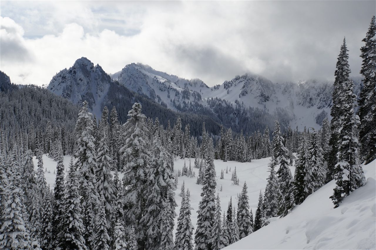
I couldn’t escape the overpowering dominance of my next National Park destination: Mount Rainier. Looming over Seattle like a lonely sentinel, this mountain is a serious addition to the skyline. Although I rarely saw Rainier from the city, it seemed to welcome me with open arms as I drove east. In order to enter the park, I had to mention the AWD capabilities of my car, say that it had legitimate tires, and that I had chains with me (whoops). The road to Paradise, the “town” of Park Service buildings high on the mountain, is very well maintained, but is a sustained ascent or descent through windy roads with high banks of snow and often sub-optimal driving conditions. Sam managed the climb like a champ.


By the time I reached Paradise 30 minutes later, my jaw was sore. Apparently, my mouth had been agape for the entire drive. One minute, I was driving through impenetrable pines, the next I had emerged into a stark horizon of snowcapped peaks and deep valleys. Each turn made me realize the immensity of the Mount Rainier National Park. It isn’t just the mountain. Over 260 miles of trails crisscross alpine meadows, rivers, forests, and glaciers. In Paradise, I found hundreds of people snowshoeing, sledding, and ski touring. Of the parks I have visited in the winter, this one was by far the most popular. I can see why. Moreover, I was pleasantly surprised to see that people hadn’t been deterred by the imposing nature of Rainier, a surprisingly technical peak. Adventurers of all ages and skills were enjoying the mountain in whatever ways they could. Now that is exciting!


After tromping around in my snowshoes and rolling down a big hill, I packed up and headed for Seattle. Plenty of friends to see, course work to do, and exploring to be done there! Stay tuned…
PNW Exploration Part II
4 Responses
Brad
It was really great to meet you today at Cape Horn. I hope the remainder of your journey/adventure is great! I must confess, I am a tad jealous.
susan fey
Really enjoyed the PNWonderland posts. The dam pieces are really very inspirational. We can break it. We can fix it. And, gorgeous images, per usual. XO
Jean Cronon
I learned a lot from your description showing what is happening with the removal of the dams. It was very scary to view this. What a pleasant contrast when you got to Mt Rainier!!
to Mt. Rainier!
Mary Kelly
Hey- Really wonderful post….loved the inclusion of the time lapse footage and of course
your own amazing photos as well.
Very cool.
Mary