Crisscrossing California has allowed me to see many different sides of the drought that threatens this state’s urban centers and agricultural enterprises alike. As I still have much of California to cover, I won’t share all of my conclusions just yet. That said, my drive from Sequoia NP to Pinnacles NP brought me straight across the central valley. My route angled through fields of cotton, past lines of almond trees, past pastures of grazing livestock, and around overflowing fields of lush produce. These were the irrigated landscapes that fuel the economy of this valley and feed the people of California and the world. Beyond the vivid greens and pale white blossoms of the almond trees, however, the dusty plains of neglected, un-irrigated land told a different story. Along the road, signs explained the different sides of the debate. Some asked if it was a waste of water to grow food? Other signs urged reevaluation of water usage and crop relocation. With such a stark divide written on the landscape, the signs almost felt like overkill to me. Stay tuned for a full drought write-up once I have finished my journey through California!
Since I still felt under the weather in Sequoia, driving towards the coast felt like the right decision. I figured that the weather would only get warmer, more consistent, and more sunny as I moved closer to the Pacific. I was right. An added bonus, however, was my increased access to ridiculously fresh produce. I was headed into the salad bowl of California right at the moment when my body was craving Vitamin-C… how convenient! Before I knew it, I had loaded up on oranges, tangelos, blood oranges, and grapefruit. It was exactly what the doctor ordered.
With the weather steadily improving, I found myself in Pinnacles on an absolutely beautiful day. During my time in San Francisco, a few friends had warned me that it might be hard for me to spend two whole days in Pinnacles, so I decided to maximize my day there before continuing south down the coast. Entering from the west, I immediately geared up and headed for the trail. My goal was to hike the loop trail that circumnavigates the main section of the park, allowing access to the caves and high ridges alike. With a pack full of water and snacks, I was off.


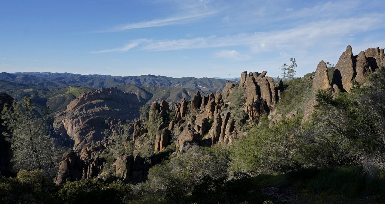
As National Parks go, Pinnacles is pretty small. That said, it packs all kinds of biodiversity and geologic excitement into its constricted footprint. The park’s name derives from the bizarre collection of monoliths that rise out of the hills like some extraterrestrial sculpture garden. Located near the San Andreas Fault, the movement between the Pacific and North American plates worked its magic on the ancient volcanic formations in Pinnacles National Park. More than 23 million years ago, the Neenach Volcano erupted, creating massive monoliths of rhyolite and andesite. Tectonic shifting then moved a section of the volcanic fallout to its present location in Pinnacles National Park. In the 23 million years since that eruption, the San Andreas Fault has also moved a few miles to the east. The park tells a story of geologic time and shifting earth that we rarely get to experience in such an up close and personal way. I couldn’t wait to get exploring. My trail rose slowly through delightfully shady undergrowth until an extended section of switchbacks led me into the dry heat and searing rays of the sun. I began sweating instantly. Hiking through the moonscape only provided the occasional respite from the sun, so I continued quickly towards Bear Gulch and its caves that promised shade and an opportunity to replenish my water supply.

The talus caves in Bear Gulch aren’t necessarily like Mammoth Cave or Carlsbad Caverns. Bear Gulch’s caves wind through the spaces underneath collapsed pinnacles. They are disjointed and shattered, allowing light to leak in through gaps in the ceiling above. These caves are home to at least thirteen different species of bats, some of which are endangered, which means that they are actually closed for most of the winter as the bats hibernate. My luck continues to run strong though. The caves opened the day before I got there! Speaking of bats, here is another fun biological fact for you: Pinnacles National Park has the highest concentration of bees on the planet, almost 400 species call the park home.


In the cool darkness of the caves, I clumsily hopped over subterranean streams, climbed slick concrete staircases, and blindly walked across catwalks cut into the sheer walls. I had a headlamp in my backpack, but decided my eyes would adjust. Who knows whether that was a good decision… The cave system, like the park, is one of the smaller I have found in a National Park, so I couldn’t justify too much time cooling down. Eventually, I wandered back out into the baking sun. Temporarily blinded by the light of the day, I regained my composure and headed down to refill my water.

Having climbed and descended the ridge in the first section of my hike, I now had to regain the ridge to access the High Peaks section of the trail. Climbing steadily through Condor Gulch, I saw seven of the massive birds effortlessly gliding above me. The California condor has been successfully reintroduced into Pinnacles National Park and the effect is breathtaking. They ride the heat waves rising off of the exposed rock, defying gravity for what seems like hours. Despite their turkey-like heads, condors are some of the most graceful birds I have seen on my trip thus far. Hiking up the ridge, the birds danced in front of me, almost mocking my sweaty efforts to gain elevation. Regrettably, I didn’t have my telephoto lens with me, so I have no condor photos to share. That said, their movement is what is so captivating, something that a picture might struggle to portray. I guess you will just have to take my word for it.


Skirting the highest ridge of pinnacles, I followed the trail around to the backside of the park where I had begun my day. I found my section of switchbacks just where I had left them, although the surrounding hills now protected them from direct sun. Shortly thereafter I found myself in that lush valley where this adventure had begun. With a small stream babbling along the valley floor, it was impossible not to be overwhelmed by the peacefulness of the swaying trees, soft grasses, and the shifting colors in the late afternoon sun. I wish every hike could begin and end with a valley like that.

Although there are certainly more treasures hidden among the towering rocks of Pinnacles, I think they are best explored with a climbing buddy. Next time I am in San Francisco, I will definitely make another trip down this way. That’s all for now from Pinnacles though. Time to hit Big Sur!
Map for the Day
Leave a Reply